Indian Institute of Technology Madras
BS Degree Programme · Examination & Study Paper
Tools in Data Science
Geospatial analysis & routing
Examination Instructions & Guidelines
- Solve on notebook/paper first before checking solutions.
- MCQ: Exactly 1 option is correct. Negative marking applies.
- MSQ: One or more options correct. Select all to score.
- Scientific calculator allowed for all calculations.
- Official answer key is sealed at the end of this sheet.
End Term · 31 Aug 2025 (FN)End Term
- Q1MCQ1 Mark·Choose one option
For a geospatial analysis project involving buffer operations, spatial joins, and interactive mapping, which combination of libraries provides the most comprehensive solution?
- AMatplotlib + NumPy + Pandas
- BGeoPandas + Shapely + Folium
- CPlotly + Seaborn + SciPy
- DBokeh + NetworkX + PyProj
Read the passage below, then answer Q2–Q3
Scenario 2: Smart City Traffic Management System
A metropolitan city is implementing a real-time traffic management system that processes data from IoT sensors, traffic cameras, and GPS devices to optimize traffic flow across 500+ intersections.
System Architecture:
● IoT sensors at intersections (Lat/Long coordinates provided)
● Central processing hub: (28.6139^o N, 77.2090^o E)
● Real-time data streams: traffic density, weather conditions, accident reports
● ML models for traffic prediction and route optimization
Based on the above data, answer the given subquestions.
Q2MCQ1 Mark·Choose one optionWhen optimizing traffic routes for emergency vehicles during peak hours, which algorithmic approach best balances computational efficiency with real-time requirements?
- ABrute force calculation of all possible routes
- BA pathfinding with dynamic edge weights based on real-time traffic data
- CRandom route selection
- DStatic pre-computed emergency routes
- Q3MCQ1 Mark·Choose one option
The system calculates distances between intersections for route optimization. What is the primary computational advantage of implementing the Haversine formula in the traffic management context?
- AProvides accurate great-circle distances for GPS coordinates without requiring road network data
- BCalculates exact travel time including traffic conditions
- CDetermines elevation changes for fuel efficiency
- DMeasures road surface quality for vehicle routing
End Term · 31 Aug 2025 (AN)End Term
- Q4MCQ1 Mark·Choose one option
For analyzing urban traffic patterns using GPS coordinate data, which combination of Python libraries provides the most comprehensive geospatial analysis capabilities?
- APandas + Matplotlib + NumPy
- BGeoPandas + Shapely + Folium + Contextily
- CPlotly + Seaborn + SciPy
- DBokeh + PyProj
Read the passage below, then answer Q5
Scenario 2: Smart Manufacturing Quality Control System
An automotive manufacturer implements an IoT-based quality control system that monitors production line metrics, detects defects in real-time, and optimizes manufacturing processes across multiple assembly plants.
System Architecture:
● IoT sensors at production stations (coordinates provided for each plant)
● Quality control hub: (42.3601^o N, 71.0589^o W)
● Real-time data streams: temperature, pressure, vibration, visual inspection
● ML models for defect prediction and process optimization
Based on the above data, answer the given subquestions.
Q5MCQ1 Mark·Choose one optionThe system uses GPS coordinates to optimize supply chain logistics between plants. What is the computational advantage of using the Haversine formula in manufacturing logistics?
- AAccurate distance calculations for optimizing transportation routes and delivery scheduling
- BCalculating exact production times
- CDetermining equipment maintenance schedules
- DMeasuring network latency between plants
End Term · 13 Apr 2025 (FN)End Term
- Q6MSQ2 Marks·Choose all correct options
A researcher needs to perform spatial data operations like buffering and visualize the results on an interactive map. Which libraries would be most suitable?
- AGeopandas
- BFolium
- CMatplotlib
- DShapely
Read the passage below, then answer Q7–Q8
Scenario 2
Wildfire Emergency Evacuation Planning
Background:
A wildfire is threatening a rural mountain region, and emergency services need to coordinate evacuation routes for four remote communities. The Emergency Management Center is located at a central command post, and must plan the most efficient evacuation route to ensure rapid and safe community evacuation.
The four communities are:
Pine Ridge Settlement (Latitude: 38.7456, Longitude: -120.8765)
Mountain View Village (Latitude: 38.6987, Longitude: -120.9234)
River Valley Community (Latitude: 38.7123, Longitude: -120.7654)
Forest Creek Hamlet (Latitude: 38.6789, Longitude: -120.8901)
Central Command Post Location:
(Latitude: 38.7200, Longitude: -120.8500)
Based on the above data, answer the given subquestions.
Q7MCQ1 Mark·Choose one optionWhich computational tool would be MOST APPROPRIATE for optimizing the complex evacuation route considering multiple communities?
- AMicrosoft Excel for manual distance calculations
- BGoogle Maps for route visualization
- CPython libraries like NetworkX or OR-Tools for route optimization
- DQGIS for static route mapping
- Q8MCQ1 Mark·Choose one option
What is the primary advantage of using the Haversine formula in emergency route planning?
- ACalculating exact road distances
- BDetermining travel time under specific conditions
- CComputing great-circle distances on a spherical Earth
- DMeasuring elevation changes in mountainous terrain
End Term · 22 Dec 2024 (FN)End Term
- Q9MSQ1 Mark·Choose all correct options
You are asked to create an interactive map showing the locations of COVID-19 vaccination centers. Which of the following Python libraries would be most useful for geospatial analysis and visualization?
- AGeopandas
- BQGIS
- CFolium
- DOpenStreetMap
Read the passage below, then answer Q10–Q14
Scenario 2
Geospatial Distance Calculation for Emergency Response
Background:
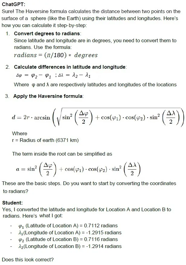
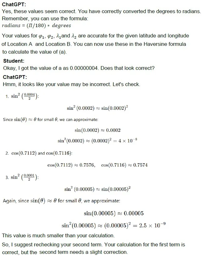
As part of the course, you have been introduced with the concept of Haversine formula and its use in distance calculations between two points. The below is a transcript of the conversation between a student in TDS and ChatGPT while they were trying to solve the questions in Graded Assignment 6.
Student-ChatGPT Discussion Thread
Student:
Hi, I have two locations with the following coordinates:
- Location A: Latitude = 40.748817, Longitude = -73.985428
- Location B: Latitude = 40.761293, Longitude = -73.982294
I need to calculate the distance between them. I heard that the Haversine formula can be used for this. Can you help me understand how to do this step-by-step?
Student:
Ah, I see my mistake. I’ll correct the second part and continue with the calculation. Thanks! Assume that the student got the full marks for the answers in Graded Assignment 6. Use the information given in the above conversation to answer the given subquestions for the given scenario.
Emergency Medical Supply Delivery in Storm-Critical Zones
Background:
The city of Hillton has been hit by a severe storm, leading to power outages and road closures. The city’s emergency response team is tasked with delivering medical supplies to four hospitals located in different areas of the city. Due to time constraints, the response team wants to find the most optimal route to minimize travel distance.
The team has access to a file called hospital_locations.csv, which contains the following information:
- Hospital Name
- Business ID
- Latitude
- Longitude
The 4 hospitals in need of supplies are:
1. North Hill Hospital (Business ID: 2103) — (Latitude: 40.7128, Longitude: -74.0060) 2. Eastview Medical Center (Business ID: 2158) — (Latitude: 40.7306, Longitude: -73.9866) 3. Westbrook Hospital (Business ID: 1987) — (Latitude: 40.6995, Longitude: -74.1745) 4. Southend Clinic (Business ID: 2895) — (Latitude: 40.6526, Longitude: -73.9497)
The emergency response team is currently stationed at the Emergency Supply Center at (Latitude: 40.7222, Longitude: -74.0134). The team must deliver supplies to each of the 4 hospitals and return to the supply center.
The goal is to minimize the total distance traveled.
Based on the above data, answer the given subquestions.
Q10MSQ1 Mark·Choose all correct optionsThe first step is to calculate the distance (in meters) between the Emergency Supply Center and each of the 4 hospitals using the Haversine formula. Which of the following is the correct distance (in meters,most closest) from the Emergency Supply Center (Latitude: 40.7222, Longitude: -74.0134) to Eastview Medical Center (Latitude: 40.7306, Longitude: -73.9866)?
- A1,975 meters
- B2,346 meters
- C2,925 meters
- D3,254 meters
- Q11MCQ2 Marks·Choose one option
The response team wants to deliver to the nearest hospital first. Which of the following hospitals is closest to the Emergency Supply Center (Latitude: 40.7222, Longitude: -74.0134)?
- ANorth Hill Hospital (Latitude: 40.7128, Longitude: -74.0060)
- BEastview Medical Center (Latitude: 40.7306, Longitude: -73.9866)
- CWestbrook Hospital (Latitude: 40.6995, Longitude: -74.1745)
- DSouthend Clinic (Latitude: 40.6526, Longitude: -73.9497)
- Q12MCQ2 Marks·Choose one option
The response team has decided to follow the "nearest hospital first" strategy. The team first goes from the Emergency Supply Center to the nearest hospital identified in the previous question, then proceeds to the next closest hospital from there, and so on until all hospitals are served. Based on this strategy, which of the following represents the correct order of hospitals to visit?
- ANorth Hill Hospital → Eastview Medical Center → Southend Clinic → Westbrook Hospital
- BEastview Medical Center → North Hill Hospital → Southend Clinic → Westbrook Hospital
- CNorth Hill Hospital → Southend Clinic → Eastview Medical Center → Westbrook Hospital
- DEastview Medical Center → Southend Clinic → North Hill Hospital → Westbrook Hospital
- Q13MCQ1 Mark·Choose one option
The response team realizes that following the "nearest hospital first" strategy may not be optimal. They consider using a more advanced strategy where they plan the entire route before starting. The team uses geospatial optimization tools to find the shortest route using a "traveling salesperson problem (TSP)" approach. Which of the following tools would be the most appropriate for implementing this route optimization?
- AQGIS to calculate the optimal route using the shortest path network analysis tool.
- BExcel to calculate the distances between each pair of hospitals and identify the optimal route manually.
- CPower BI to visualize the hospital locations on a map and create an optimized route.
- DA TSP algorithm using Python libraries like NetworkX, SciPy, or OR-Tools to calculate the optimal route.
- Q14MCQ1 Mark·Choose one option
Which of the following best describes the purpose of using the Haversine formula in geospatial analysis?
- AIt calculates the distance between two points along a road or path on a map.
- BIt computes the distance between two points along the surface of a sphere.
- CIt measures the Euclidean distance between two points in a Cartesian coordinate system.
- DIt calculates the total travel time between two points based on traffic conditions.